Zambezi River
RiverAbout
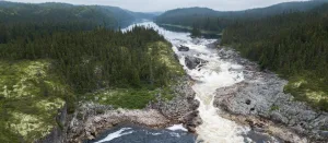
The Zambezi River is Africa's fourth-longest river, stretching approximately 2,574 kilometers from its source in Zambia to its mouth in the Indian Ocean. It flows through six countries: Zambia, Angola, Namibia, Botswana, Zimbabwe, and Mozambique. The river is renowned for its diverse geographical features, including the iconic Victoria Falls and the Chavuma Falls. The Zambezi supports significant hydroelectric projects, such as the Kariba and Cahora Bassa Dams, which are crucial for regional energy production. The river's course is divided into three sections: the Upper, Middle, and Lower Zambezi. Each section offers unique landscapes and ecosystems. The Middle Zambezi features the dramatic Batoka Gorge, known for its challenging rapids. The Lower Zambezi flows through a broad valley, eventually forming a delta as it approaches the Indian Ocean. The Zambezi River supports a rich biodiversity and is a vital source of water and energy for the region. Its basin covers over 1.3 million square kilometers, impacting the lives of millions of people across southern Africa.